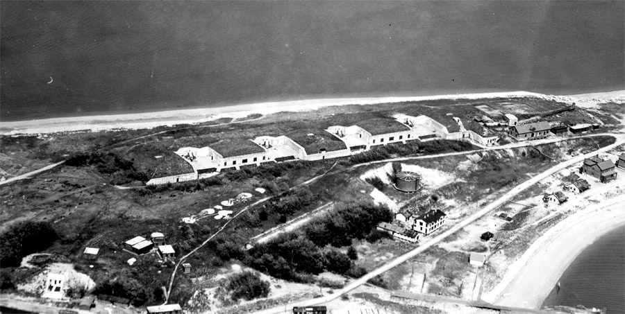
This undated photo is from NARA, via CDSG, and appears to have been taken about 1926. It looks southeasterly. The gun batteries are identified without arrows. The Coast Guard's range lights are at bottom, with the front light at left. These were destroyed in 1939 in an expansion of the fort. Btty Weir, at right, was later destroyed by wave action and is now ruins. Btty Terrill, at bottom, is now also severely eroded. Btty Vincent, originally 4 6-in guns, later mounted 3-inch AA guns and then smaller calibre AA guns during WW2. The 90mm AMTB Btty 943 was located during WW2 just north of Btty Terrill, at bottom. Photo has been cropped, adjusted, and annotated by CoastDefense.com.
This photo looks southeasterly at the four 10-inch M1900 guns of Bttys Morris (left) and Burbeck (right), with their guns still in place. This viewpoint clearly shows the wider, 2-tier and snub-nosed fire control structures side by side at lower left and the above-ground (old) telephone switchboard building southwest of (behind) them. The new bomb-proof switchboard bunker is the bright white construction at lower left. The searchlight shelter and track are at upper right. The large building at the extreme right, west of the road, is NCO quarters, and the white building with the dark roof, below the water tank, is likely a barracks, with a mess to its left. The four gun positions of Btty Vincent are at center left, with the CRF station position next to them in line to the right. Photo, from NARA via CDSG, has been cropped and adjusted by CoastDefense.com.
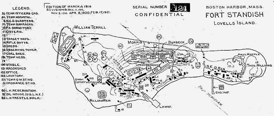
This map, from NARA via CDSG, was drawn by the Army Engineers, and helps to interpret the photos in Slides 1 and 2, although the photos appear to be 5-10 years more recent than the map. The battery numbers for the fire control positions are from the "old" series of the early 1920s, and it appears that the battery assignments of these stations shifted back and forth as Ft. Standish aged. Photo cropped and adjusted by CoastDefense.com.
This undated photo looks southwesterly long the range lights that used to exist at the north end of the island (see Slide 1). The small structure between the two lights is the oil house, and the walkway at right in the distance ran to the lighthouse keeper's house. The photo comes from the Coast Guard: http://www.uscg.mil/history/WEBLIGHTHOUSES/
lovellsisland.JPG.
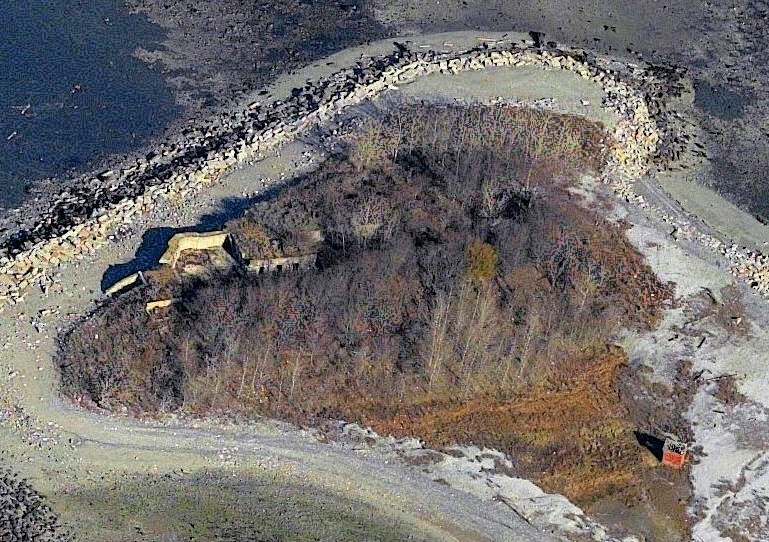
This image, from Bing Maps and dated c. 2011, shows the present situation at the north end of Lovells Island. The gun position on the left is Gun 3 of Btty Terrill, with its magazines to its right. The rest of the battery is hidden in the trees. The small brick structure at lower right is the oil house, surviving from the pre-1939 range lights.
Additional sidebar
Lorem ipsum dolor sit amet, consectetuer adipiscing elit. Quisque congue tristique eros.